Wednesday, July 10, 2019

Day 55: Orvieto to Bagnoregio


I must admit that I felt a little sad to be leaving Orvieto. It is such an intriguing city, with its winding medieval layout and its beautiful tufa buildings, that I was reluctant to continue. Even with our extra rest day I felt that we had barely begun to experience the possibilities of this gem. Orvieto has moved to the top of my list of favorite towns and cities of the trip.


Nevertheless, our rest day was over and it was time to continue to Rome. As noted yesterday, there will be no more rest days until we reach the Eternal City and the end of the Via.


We began the stage by departing Orvieto and making our way down the south side of the tufa cliffs. The early part of the route followed the main road, until we reached a point where a small road departed to the left. Experience has left me with a small cringe whenever the Via suddenly takes an innovative route away from a main road. My hesitation was again justified. The road ran down to a small house and vanished. A trail (of sorts) continued past the house and was consumed by a patch of blackberry brambles and stinging nettles.


Once more into the breach, dear friends.


We bushwhacked down the hill, flailing violently away at the overgrown path with our hiking poles. Mary’s legs got slashed up quite badly by some renegade blackberry vines, and then she managed to stumble into a nettle patch and ended up with a nasty rash all over her leg.


Mary of the Brambles


We whacked away gamely and ultimately reached the bottom of this lovely path --- where it crossed the main road we had previously been walking on.


Medieval Aqueduct


The trail from this point followed a medieval aqueduct that had been built to supply Orvieto with water. It ran steeply uphill from the point at which we emerged from the bramble patch, and the next three kilometers consisted of a vigorous ascent up the ridge that stands to the south of Orvieto. We knew it was coming, however, and were mentally prepared for the climb. The ascent began to soften by the time we reached Rubello Castle, a medieval castle built to control the road south from Orvieto.


Castel Rubello


We stopped for an iced tea in Porano, and then continued south on the altopiano. The weather was some of the best that I have seen in weeks: heavy grey clouds had rolled over the sun, and a cool breeze played across our faces. It has been quite a while since hiking has been pleasurable --- it was nice to be reminded that it could be.


We walked through country lanes, past farm fields, and ultimately made our way down into the town of Lubriano. As we approached the center of the town, we saw many bottegas carved into the tufa cliff face and closed off with small doors.


Bottegas


We also had our first view of Civita di Bagnoregio from Lurbiano. The Civita is one of the wonders of the modern world. It is a small town built on an eroding tufa prominence. Originally an Etruscan settlement, wind and water have gnawed away at the base of the town, sending building after building crashing into the valley below. Today, only a handful of people live there, and it is reached by a bridge that runs from Bagnoregio.


The sun had emerged by the time we reached Bagnoregio. We took our showers, had a little lunch, and by late afternoon, were ready to walk out to Civita di Bagnoregio.


The Bridge to Civita di Bagnoregio


Mary and I both agreed that although it was interesting, it was more like a tiny tourist attraction than a real town. Although Rick Steves wrote that this was his favorite Italian hill town, it is hard to see why. During the day it is overrun with tourists, and in the late afternoon/evening when we paid it a visit, it simply felt like a ghost town or a stage set. The city that is dying cannot hold a candle to a vibrant hill town like Orvieto. It is pretty, it is being slowly destroyed by the inexorable forces of nature, but it will not go down as one of our favorite places on the Via.


A crumbling building in Civita di Bagnoregio


Today’s Distance: 18.4 KM

Total Distance: 1055.8 KM

Monday, July 8, 2019

Days 53 & 54 - Ficulle to Orvieto


In many ways, today’s stage was very similar to yesterday’s stage. We began in a hill town, hiked down to the valley below, walked beside train tracks for a while,and then ended the day hiking up a steep hill to another hill town.


We spent a considerable amount of time on asphalt. The early part of the day was extremely humid, and a dense haze/fog obscured the peaks on the opposite side of the valley. We had made an earlier start, so conditions were reasonably good at the beginning. I am still waiting for the forecasted break in the heat wave to materialize.


Mary of the Creek


Midway through the hike, we encountered Ponte Iulio, Pope Julius’ bridge. This was originally a Roman bridge, but it was rebuilt during the reign of the pope. Today it is in fairly poor condition.


Ponte Iulio


We closed out the day with a long, steep climb up the hill to Orvieto. The city is placed on top of a hill of tufa, and is surrounded on all sides by cliffs. It was a vigorous hike to end the day.


Approaching Orvieto


Orvieto is a gorgeous city of stone. All of the buildings are made of tufa blocks, and since the layout has changed little since the Middle Ages, it makes a most favorable impression. We had heard that it was a favorite tourist destination and likely to be swamped by people. This was not our experience. Either there were not many tourists around during our visit, or the city absorbed them with aplomb.


We took our last rest day here, and in the early morning, eager to see as much as we could before the heat became oppressive, we began our exploration. At the eastern end of the town we found the Pozzo di San Patrizio (St Patrick’s Well).


This well was commissioned by Pope Clement VII in 1527. The pope had fled to Orvieto for security after Rome had been sacked by a germanic army. Because Rome no longer seemed a safe place for the pontiff, plans were made to create a refuge for him in Orvieto.


Orvieto was very difficult to storm, but it was essential that it have a secure source of water. Consequently, the pope ordered the well.


It took ten years to carve this extraordinary well out of the stone. It is 53 meters deep and a consistent 13 meters wide all the way to the bottom. Not only that, it is lined with two circular staircases hewn out of the rock, a double helix of stairs. One staircase is for traffic descending, the other for ascending traffic. The staircases are wide enough for mules holding water jugs, which was the primary method of bringing water to the surface.


Well Windows


We descended into the gloom. Windows have been cut between the central shaft of the well and the stone staircases, so you can mark your progress as you descend. It also became cool very quickly, a pleasant change from the muggy weather at the top.


We reached the bottom, where there is a pool of water, filled with tourist coins. We were able to look back up the central shaft to the surface. I think a chain of buckets and windlasses would have been a more effective way to transport water than mules. In either case, the pope was never forced to take refuge in the city, so the labor was possibly in vain. It is amazing though. A Latin inscription on the well summarizes the effort nicely: what nature failed to supply, hard work provided.


The View from the Bottom


We then made our way to the area around the Duomo. There we visited the Etruscan museum and were treated to a wide range of artifacts discovered in and around the city. Orvieto began its life as the Etruscan city of Velzna. It has a rich archeological heritage and many fine objects were on display in the museum.


Today's Etruscan Selfie


One of the most fascinating aspects of Orvieto are the excavations beneath the city. The volcanic material that forms the base of the city is extremely soft, and for millennia, the residents have been burrowing beneath the surface. It is estimated that there are more than 1,200 cave complexes beneath the city, many of them reached from the basements of  the houses and buildings.


Our next stop was a tour of underground Orvieto. We went below the city into two caves. The first cave complex contained a medieval olive press --- olives are picked and the fruit is pressed during the winter, so this underground cave was an ideal place for this work. We also saw an Etruscan well that was used to supply the city during a siege.


The second cave complex consisted of rows of square boxes carved into the stone, roosts for pigeons. The birds were given free lodging, and they supplied guano and meat for the owners of the caves. The caves were fascinating and we enjoyed the tour immensely.


Stone Pigeon Boxes


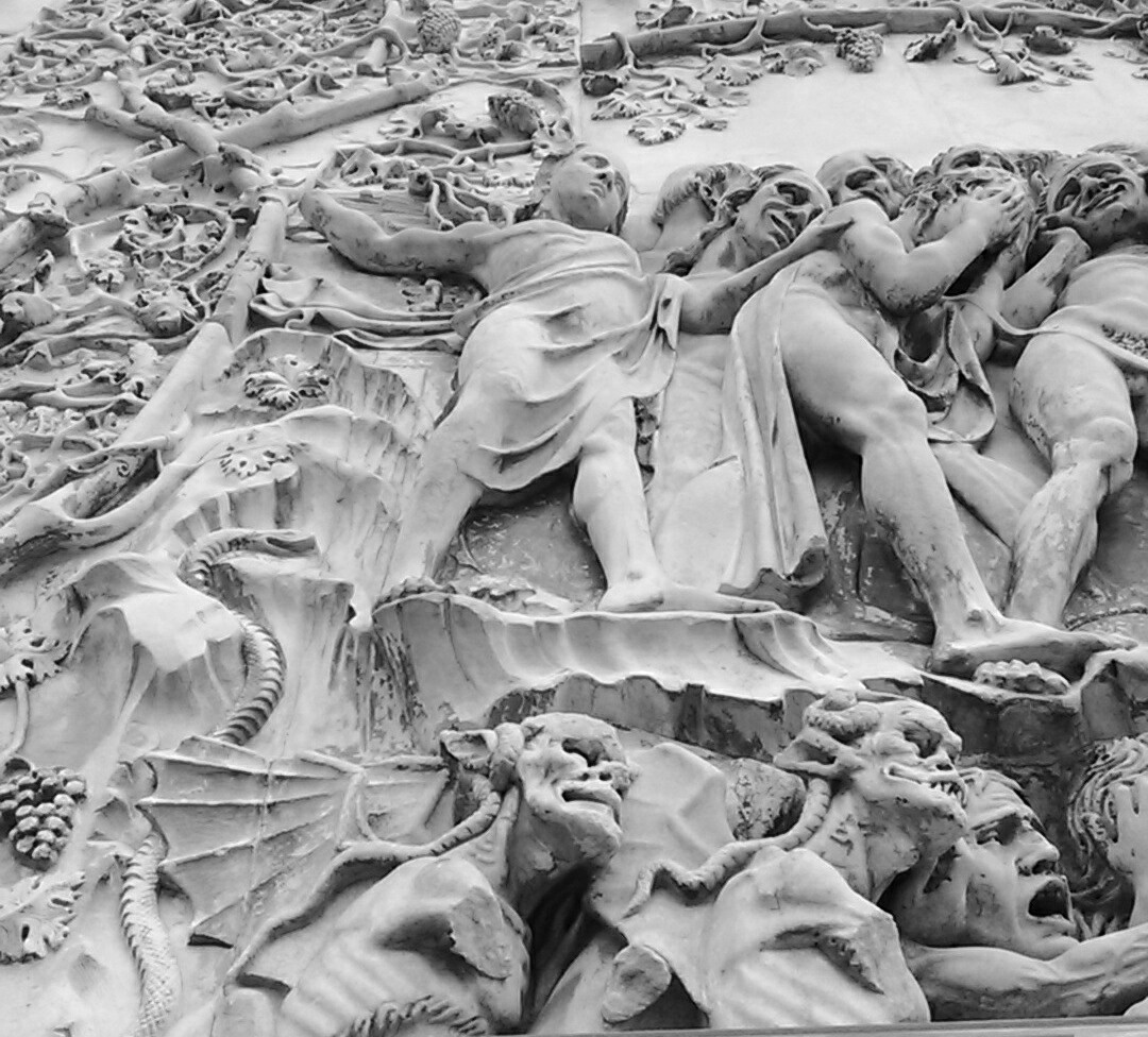
The day was becoming insupportably hot, so we ended our tour with a visit to the Duomo. Mary was quite taken with the exterior of the building, which uses two different colors of stone to create a “lego” effect, very similar to the cathedral in Siena. The front is magnificent, and I was particularly absorbed by the carved bas-relief figures illustrating the major events in the Genesis story.


Bas-relief, Duomo Exterior


The interior was fine, but a little subdued, except for the chapel of the Madonna of Saint Brictio. This chapel is rather stunning. It features the work of Renaissance painter Luca Signorelli. His Last Judgement in the chapel is said to have been a source of inspiration for Michelangelo’s similar piece in the Sistine Chapel.


Pieta


The day had grown too hot for sane people to be about. After a fine pizza lunch, we retired to our apartment to rest, wash clothes, and write blog entries.


Duomo Exterior


Orvieto will be our last rest stop. From here it is eight days to Rome


Today’s Distance: 24 KM

Total Distance: 1037.4 KM

Sunday, July 7, 2019

Day 52 - Citta della Pieve to Ficulle


Although we had a lovely evening in Citta della Pieve,  the night that followed was one of the poorest yet.


Our apartment did not have an air conditioner, and its windows looked out over a major piazza. Our owner's solution: around 9:00 PM, open the window and let the fresh air in. This advice came during the middle of a major heat wave.


When we let the fresh air in, we also let in all of the noise of a Friday night. To shorten this diatribe to footnote length, it was loud. And it remained loud until well after 1:00 AM. Then, after the people's voices had finally fallen quiescent, the mosquito came.


Let us draw a curtain over that entire bleak night and move along.


We wanted to make an early start on today's stage. It was supposed to be very hot again, and we had a moderate distance to travel. We managed to leave Citta della Pieve before 8:00, and walked down a long gravel road out of town. After a couple of kilometers, we were able to see the city from across a valley. It was a beautiful sight, with its stone towers and churches filling the skyline,  far more impressive than what we saw on the way into town.


Citta della Pieve


Today's stage was incredibly straightforward. We followed a gravel road down to the valley, and then we walked on a long straight road that paralleled the railroad tracks. We walked through farmland, wheat fields, and freshly mown hay.


Mary of the Straight Road


Eventually we reached the town of Fabro Scalo, where we left the sanctioned Via route to wander into town to find a bar for cold drinks. I had an iced tea, Mary had a water.


Refreshed, we returned to the road. We crossed the Fiume Chiana (Chiana River) and began a slow ascent on asphalt to Ficulle. This took about an hour on an ever-steepening hill. Ultimately, however, we made it.


Ficulle is another tiny, beautiful brick and stone hilltop town. It is one of those places you would never come on a tour bus, but it is rather beautiful. We were able to find a supermercato to grab something for a late lunch, and, thankfully, the only restaurant we could find was open for business.


In the evening, people bring chairs out into the streets, and sit and chat until the light goes out of the sky. Mary had met our neighbors, so when we returned from dinner, we were able to engage them in a lively Italian conversation.


La Rocca, Ficulle


One more day to Orvieto and our last rest day before Rome.


Today’s Distance: 21.3 KM

Total Distance: 1013.4 KM

Friday, July 5, 2019

Day 51 - Paciano to Citta della Pieve


The promised cooling trend has yet to take effect. A few thunderstorms played in the valley near Paciano yesterday, but these quickly dissipated and the day dawned bright, clear, and expected to be hot. The weather boffins were predicting a high temperature of 97 F.


Normally in this situation, we would try for an early departure so that we could put as many kilometers under our feet before the heat became intolerable. Today’s stage, however, was fairly short, and we didn’t want to arrive before our noon check-in time. The other factor was that our hotel breakfast wouldn’t begin until 8:30.


We further complicated matters by having a long chat with our host about the hotel business and the opportunities and pitfalls that emerge when soliciting tourist traffic. As it turned out, we didn’t head down the road until 9:30, which is now our record for late starts.


The road descended from Paciano, and then would spend the next ten kilometers simulating a roller coaster: some times we went up, other times down. Once again we were among olive groves, and other crops.


After a walk on a busier road, we turned off onto a gravel road. It ran past a field of cows. The flies, eager for fresh meat, swarmed me. Most unpleasant.


Passing the cow pasture


The gravel road narrowed to a single track through the trees, and we began to climb the long hill to Citta della Pieve. This is another stretch of the Via that could use some machete work, as the blackberry vines are weaving together to close the trail.


After a steep uphill section, we broke out on a plateau and caught our first view of the town.


There is considerable disagreement about the origins of Citta della Pieve. The name literally means “city of the parish church (Pieve).” Some scholars believe that there was a settlement here during the Etruscan period, others argue that people did not live here until much later. The Citta seems to have come into existence in the thirteenth century. When seen from the air, it is shaped like an eagle, the symbol of the German Emperor Henry II, who controlled this region when the town was founded. What stands today, a large collection of brick churches, palaces, and other town buildings, were all constructed as the Renaissance was beginning. The city has changed little since then, and it retains its late medieval character.


Medieval architecture


The "pieve" that gives the city its name is, today, the Duomo. Originally it was a parish church dedicated to the Milanese martyrs Protasius and Gervasius.


Today it holds two paintings by Perugino, the Renaissance artist who was born in the city.


Perugino, the baptism of Jesus


After visiting the Duomo, Mary and I wandered through the winding alleys between the tall brick buildings. Citta Della Pieve was once a center of brick manufacturing for Tuscany and Umbria, so when the time came to build their own city, they had no shortage of materials. Among these alleys is Italy's narrowest alley, the Baciadonne (kiss the women). This alley is said to be so narrow, that a man leaning out a window on one side can kiss a woman on the other. We didn't have access to the windows to test this proposition, but it certainly seems plausible.


Mary in the Baciadonne


It is a fascinating and unexpectedly beautiful town.


Today's Distance: 15 KM

Total Distance: 992.1 KM


Thursday, July 4, 2019

Day 50 - Pozzuolo to Paciano


We had a late start this morning. The hotel did not begin serving breakfast until 8:00, and because we were a little short of the town center of Pozzuolo, we did not pass through the official starting point for this stage until 9:00.


There is a small possibility that the brutal heat, which has gripped Italy and made this last third of the walk difficult, may be waning. The long range forecasts for next week show a cooling trend, with high temperatures predicted to stay in the eighties. That would be nice.


Most of the morning was on asphalt. We wandered across the rolling Umbrian hills. Everything was going well until we took the hiker’s bypass through the small town of Casamaggiore. We had been walking on a mildly busy provincial road. The book offered a short opportunity to get off the busy asphalt, and walk past the church of the Madonna della Neve (Mother of Snow). Caught in the day’s heat, I found it difficult to believe this portion of Umbria had ever seen snow. Nevertheless, I suppose it was possible.


Madonna Della Neve


We looked at the exterior of the church (which was locked), and then proceeded off on one of the Via’s exciting alternate paths. This led down a short dirt road, and where the road turned to the left, two arrows indicated that we should continue straight ahead, down a hill into an olive grove.


At first we were optimistic as someone had mowed the path, and the way seemed self-evident. This was a ruse. I quickly discovered that this lovely mowed path simply circled the outer edge of the olive plantation and brought us back to the starting point. Meanwhile, Mary stepped on something brambly and was picking thorns out of a vicious cut.


Maybe we should go straight ahead, we thought. This led us to a field of sunflowers. The guidebook was useless. The waymarks were non-existent. Once again we had wandered into one of those special Via places, from which it is impossible to extricate oneself without retracing our steps, or resorting to the GPS.


I am beginning to formulate a new rule: any stage that cannot be navigated without a GPS is not complete. Someone needs to return to this delightful grove and tack up a few waymarks to guide those who have never been here before.


Out came the GPS. The guidebook mentioned a road, and I saw one flanking the side of a motocross track across the valley. “Let’s work our way through the fields to that road,” I told Mary, “and then we can get back to the main road.”


I pushed my way through a thicket of tangleweed and ended up covered with burrs. Mary was still picking thorns out of her leg. Ultimately, to make a long story short, we made it into the motocross park.


“How eerily quiet,” I thought to myself as we climbed our little road that flanked the racetrack. “I wonder how they keep people out of here when the course is closed. I wonder if it is going to be easier to get in than to get out?”


We followed the road to the top of the hill, and, you guessed it, a six foot tall steel gate. It was padlocked. It was high. I looked at Mary. “Can you get over that if I help you?”


The Gate


We stared back the way we had come, though tangleweed, sunflowers, and thorny traps.


Somewhere back there was the correct path


“I’ll try,” she said.


I was able to boost her over. I passed across the backpacks, and then vaulted the gate in a single bound. Maybe it took two.


In any event, we were free again. In hindsight it seems amusing. In the moment I was less inclined to laugh. Much later, while scanning the updates to the route on the Via Romea Germanica website, we noticed that it says that the bypass through Casamaggiore is no longer possible. Obviously we bear a large share of the blame for not reading that notice before we set off, but it is still the case that out on the main road there is a waymark arrow pointing to Casamaggiore. In Casamaggiore there is still a waymark arrow pointing down the gravel road, and at the curve in the gravel road, there are two waymark arrows pointing down into the olive grove of despair. If you are going to close part of the route, someone needs to go out with a razor blade and scrape off the arrows. It is not enought to simply put a note on a website.


We rolled off the Umbrian towns in the heating day. A strange fact: most of these towns (all of those we encountered in this stage) don’t seem to have public water fountains for refilling water bottles with cool acqua. I don’t understand it. As a result, we must carry several bottles to get us through the day, and after several hours in the sun, those last two bottles are ready to brew tea. What a refreshing thing to drink 100+ degree water on a day when the air temperature is nearly that much.


Mary of the Dusty Road


Before Vaiano we passed an Etruscan tomb. This tomb was discovered when they were building the road.


Unfortunately, it was locked up, so we had to content ourselves by studying the signboards.


Locked Etruscan Tomb


We crossed under the railway line (less than an hour by train to Roma), and then began a hard march up the hill to Paciano. Midway up this hill I simply ran out of steam. I had been sweating rivers all day long, and I suddenly felt exhausted. My stomach felt queasy. I could barely crawl along the last kilometer. This is unusual for me: I usually finish the day strong. I don’t know if it was the heat, the hills, or dehydration, but it took me a long time to reach our goal.


Nevertheless, I made it.


Today’s Distance: 23 KM

Total Distance: 977.1 KM

Wednesday, July 3, 2019

Day 49 - Cortona to Pozzuolo


After our rest day in Cortona, it was time to return to the trail. The stage to Pozzuolo appeared to have relatively easy terrain, although it would be one of the longer remaining stages (about 24 KM).


We left Cortona as the sun was beginning to assert itself. We climbed through the city to the Piazza Garibaldi, and then began to descend toward the plain to the south of the city. The early going was very pleasant, as we were mostly in the shade.


Cortona Receding


As the suburbs of Cortona faded around us. Soon we were back in open (and sun-blasted) farm country. We hiked toward the little town of Ossaia, which backs up against a ridge. On the other side of the ridge is Lake Trasimene, the site of one of the most important battles in Roman history.


In 217, during the Second Punic War, the Carthaginian general, Hannibal, had invaded the Roman empire from the north and was marching south toward the city. In a very shrewd military ploy, Hannibal arrayed his army on the ridge to the north of Lake Trasimene, and lured the Roman army, under the leadership of Gaius Flaminius, into an ambush. Hannibal’s forces fell upon the Roman army as they passed between the lake and ridge, and they were able to trap the Romans with their backs to the lake. More than 15,000 Romans were slaughtered or drowned. Another 15,000 were captured. It was one of the worst defeats in Roman history.


I had hoped that the Via might wander through this historic battlefield, but much to my dismay, after passing through Ossaia, it turned west and headed for the wrong side of Lake Trasimene.


As we passed under the railroad line, one of the high speed Frecciarossa trains howled past. The train would probably be in Rome within the hour. We still have two more weeks on foot.   


Farm Country


The rest of the stage was a long hike through farmland. For the first time we saw fields of sunflowers.


We also saw grapes, which I suspect are the basis for my favorite red wine, Montepulciano.


Montepulciano Grapes


Ultimately, the day became an endurance match with the sun. Walking exposed to the full blast of Sol, we slowly withered. Fortunately, just when all seemed lost, we reached the town of Petrignano del Lago. There wasn’t much there, but on the road out of town we found a bar. Cold drinks all around. Mary drank two bottles of water, while I had a water and an ice tea.


Refreshed, we were able to resume our trek south, and in much less time than I had anticipated, we reached our destination. Cumulus clouds have been massing over the nearby mountains, and it is possible that an evening thunderstorm might cool tomorrow down. One can always hope.


Mary of the Sunflowers


Today's Distance: 23.9 KM

Total Distance: 954.1 KM

Tuesday, July 2, 2019

Days 47 & 48 - Castiglion Fiorentino to Cortona


The morning dawned clear and hot. Since we had a relatively short stage ahead of us, we decided to leave a little later. At 9:00, we hiked down the hill from Castiglion Fiorentino and headed south.


The Approach to Castello di Montecchio Vesponi


After four kilometers, we started to climb the hill to the Castle of Montecchio Vesponi. The hill sits alone on the valley floor, crowned by this fortress. It is a massive and imposing structure that played a significant role in the late-medieval conflicts between Florence, Arezzo, and Castiglion Fiorentino. As we climbed the hill, I was looking forward to having a look inside its walls. Imagine my dismay when, after dragging ourselves to the top, we discovered that it was closed, and apart from an impressively high stone wall, there was nothing to see there. We circled the castle in disbelief, but there were no access points apart from a small wooden door. A sign on the door stated that there was an “archeological tour” on the second Sunday of every month, but that was it.


Castello di Montecchio Vesponi


With tears in our eyes, we started down the other side of the hill. The route passed through olive groves, and eventually we crossed a ridge and were rewarded with our first view of Cortona. My goodness. What a heartbreaking view, in both the literal and figurative sense. Cortona sits atop a small mountain. I was dismayed by the height of the hill we would need to climb (heartbreak) and could well imagine hikers having a physical heartbreak before reaching the top. It was daunting.


Nevertheless, we cinched our backpack straps tighter and began plodding up the switchbacks through the olive groves. I didn’t time it, but I would bet the last two kilometers took well over an hour to climb. Finally, however, we reached the bottom edge of the town, turned onto the Via Roma, and continued to climb to our apartment.


Cortona is an ancient town that dates back to the Etruscans. It sits at an altitude of 2,000 feet above sea level. I have read that there is only one flat road in the entire town --- every other street either descends or ascends precipitously. It is a natural thigh and leg workout.


As we hiked through the streets, I was struck by the sound of English-speaking voices. There were many American and British tourists here, and after a month-and-a-half of not hearing other English speakers, it was a bit odd. We have been well off the tourist trail and have grown accustomed to only hearing Italian.


Mary of the Slopes


We took another rest day in Cortona to ready ourselves for the last great push to Rome. The heat continued to sap our energy, so we haven’t visited as many of the sites as possible, although we did climb high above the town to the fort, and the Church of Santa Margherita.


Basilica di Santa Margherita


We also spent a considerable amount of time in the city museum, which documents the evolution of the city from its ancient origins. It was a fine museum with a particularly excellent display of Etruscan artifacts. After a lovely lunch, we retreated to our apartment to wash clothes, rest, and stay out of the 100 F sun.


Tomorrow we will be back on the road to Rome.


Stage Distance: 13.5 KM

Total Distance: 930.2 KM